Booth's Poverty map, with Turkish baths superimposed
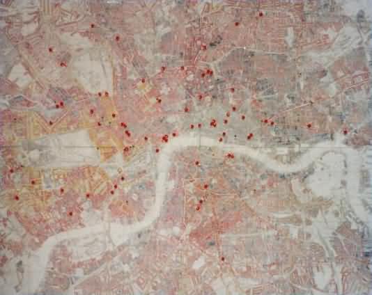
Charles Booth's Descriptive map of London poverty, 1889, comprised maps of London with the buildings on each street differentially coloured to indicate which of a series of economic levels, ranging from poverty to wealth, most closely characterised their inhabitants. The City of London was left uncoloured as the number of residents was considered to be statistically insignificant.
Here, red spots show the location of Turkish baths which opened during Queen Victoria's reign. At least 36 of these were open in 1889.
Although Urquhart and his supporters argued that Turkish baths were most needed in areas of poverty, Booth's map clearly shows that they tended to be established in the better-off areas, and that preferred locations were more often adjacent to railway stations used by commuters travelling home to the suburbs.
This page enlarges an image or adds to the information found below:
Shampooers' wages and conditions. Part 1: Charles Booth's survey
Victorian Turkish Baths: their origin, development, and gradual decline


Comments and queries are most welcome and can be sent to:
malcolm@victorianturkishbath.org
The right of Malcolm Shifrin to be identified as the author of this work
has been asserted by him
in accordance with the Copyright, Designs and Patents Act 1988
© Malcolm Shifrin, 1991-2023